Introduction
'NOAA Fisheries' Marine Recreational Information Program (MRIP) is the state-regional-federal partnership that develops, improves and implements a national network of surveys to measure how many fish anglers catch and how many trips they take. The data [MRIP] collects helps scientists and managers assess and maintain sustainable fish stocks.' - NOAA Fisheries
The MRIP consists of several independent, yet complementary surveys:
- The Access Point Angler Intercept Survey (APAIS) is an intercept survey conducted at public marine fishing access points (i.e. boat ramps, piers, beaches, jetties, marinas, etc.). This survey estimates catch per unit effort in all fishing modes.
- The Fishing Effort Survey (FES) is a mail based survey which estimates recreational shore and private boat fishing effort by utilizing the US Postal Service's list of residential addresses and the list of mailing addresses provided by licensed or registered anglers.
- The For-Hire Survey (FHTS) is designed to assess for-hire charter and headboat fishing effort.
- The Large Pelagics Survey (LPS) collects information on large pelagic fishes (tuna and sharks in Maine).
NOAA's Marine Recreational Information Program (MRIP) homepage
Survey Methods
Estimates generated from the APAIS, FHTS and FES surveys include total numbers of fish caught, released and harvested; weight of the harvest; and total number of angler trips. In 1996, Maine DMR assumed responsibility for conducting the MRIP field component in Maine, giving us the ability to increase the number of angler interviews collected beyond the NMFS requirements. This in turn has given us a significantly improved database that generates more precise estimates.
Three fishing modes are targeted during field intercept assignments: shore, private/rental boats, and charter/head boats (the latter are also referred to as "for-hire" boats). Water access sites at which recreational fin-fishing occurs are assigned activity pressure ratings and are then randomly selected each month for interview collection assignments. The frequency of site selection is based on the relative fishing activity estimated to exist at each site in a two-month block or "Wave" (May/June, July/August, September/October).
Some 2025 data highlights
Numbers of interviews
During Maine's May 1 - October 31, 2025 sampling season, 277 fishing access site assignments were completed, producing 1,435 angler interviews from boat launches, marinas, docks, beaches, jetties, breakwaters, etc. from Kittery to Eastport. When looking at the data by fishing mode, 496 shore anglers, 774 private and rental boat anglers, and 165 anglers fishing from charter boats were interviewed.
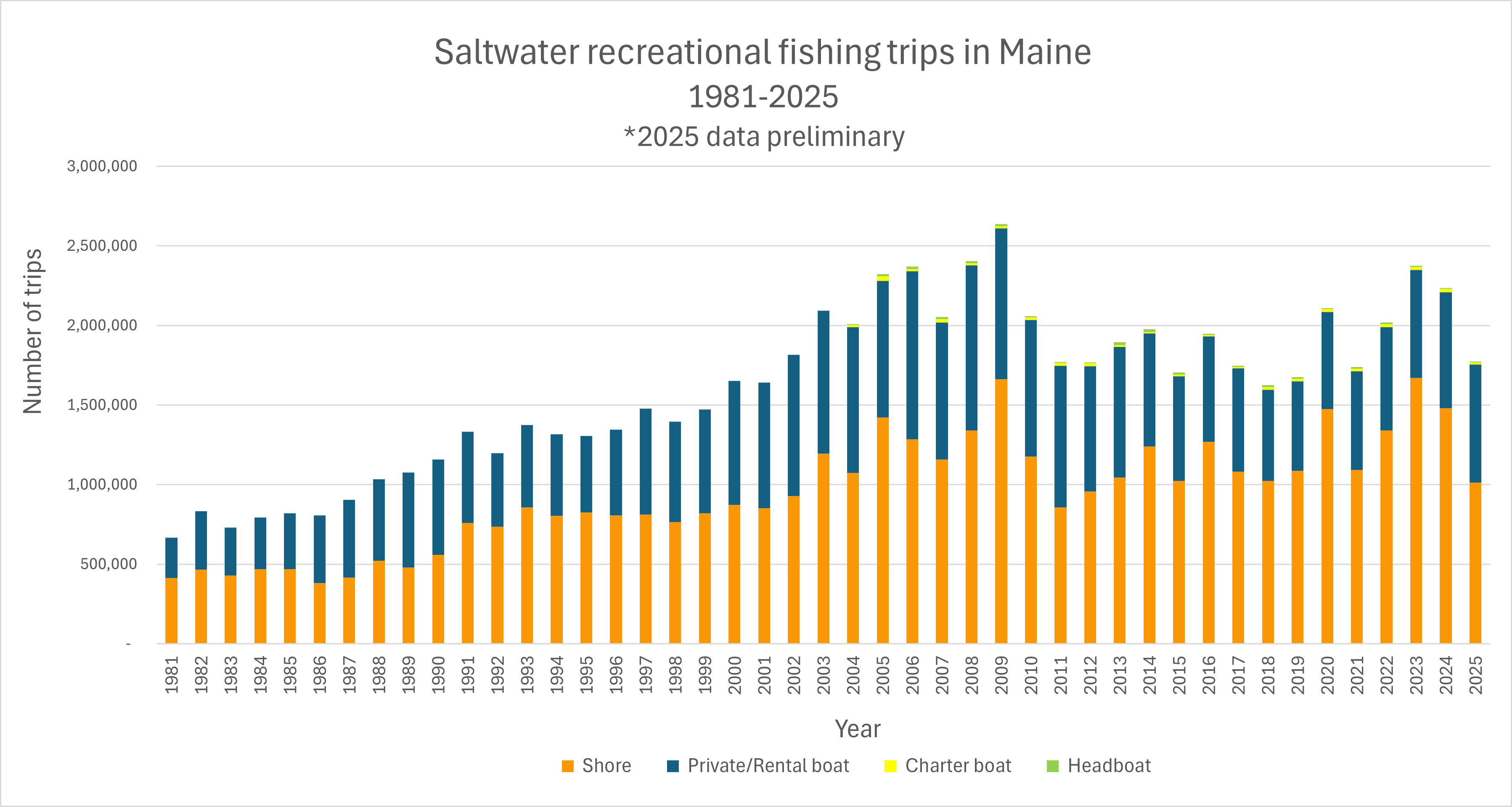
How many fishing trips did anglers make in Maine in 2025?
Estimates show anglers made 1,773,821 individual fishing trips. The following graph provides a picture of the trend in effort by mode from 1981 to 2025.
Maine's MRIP Recreational Landings Data
Below are links to recreational landings estimates for some of Maine's most popular species.
For more information about MRIP, please see www.countmyfish.noaa.gov. To query NOAA's MRIP estimates, follow the "Data Queries" and "MRIP Query Tool" links.
For More Information
For those of you looking for information on other species or similar information for other states, go to NOAA Fisheries MRIP. This site is informative and easy to use!
If during the course of the fishing season you encounter DMR staff in the field, please allow us a few minutes of your time to answer some questions about your fishing trip. Thank you!